

1860 Arkansas Mississippi and Louisiana - Johnson
Sold Out
ALVIN JEWETT JOHNSONJohnson's Arkansas Mississippi and LouisianaCompiled, Drawn and Engraved under the supervision of J. H. Colton and A. J. Johnson. Despite being advertised at steel engravings, the maps in...


1867 Map of the Mississippi River - Edward Hall
Sold Out
EDWARD HALL Map of the Mississippi Riv from St Louis to the Gulf of Mexico Continent: North AmericaCountry: United StatesState/Province: Mississippi, Arkansas, Missouri 1867Copper Plate, UncoloredSheet Size 17.75 x 6.8...


1875 Arkansas - Britannica
$35.00
BRITANNICAArkansasContinent: North AmericaCountry: United StatesState/Province: Arkansas1875Lithograph, ColoredSheet Size 10.5 x 12.5 inchesPublisher: J. M. Stoddart Co., PhiladelphiaVG+ condition with page fold as issuedCartographer/Map Maker: Britannica
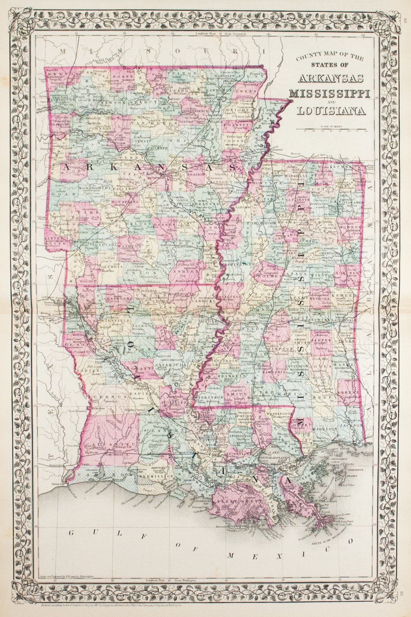

1881 County Map of the States of Arkansas, Mississippi and Louisiana - S Mitchell Jr
$125.00
SAMUEL AUGUSTUS MITCHELL JRCounty Map of the States of Arkansas, Mississippi and LouisianaOn verso Florida and New OrleansContinent: North AmericaCountry: United StatesState/Province: Arkansas, Mississippi, Louisiana1881Lithograph, Hand ColoredSheet Size 23.8 x...


1887 Arkansas - Britannica
$38.00
BRITANNICAArkansasContinent: North AmericaCountry: United StatesState/Province: Arkansas1887Lithograph, ColoredSheet Size 9.6 x 12.25 inchesPublisher: Henry G Allen and Company, New YorkVG condition with Center fold as issued, toningCartographer/Map Maker: Britannica


1887 Railroad and County Map of Arkansas
$120.00
Railroad and County Map of ArkansasContinent: North AmericaCountry: United StatesState/Province: Arkansas1887Lithograph, ColoredSheet Size 17.375 x 23 inchesPublisher: A A Grant, New YorkVG+ condition with Age toning, minor spotting, center fold...


1891 Map of Arkansas
$60.00
Map of ArkansasContinent: North AmericaCountry: United StatesState/Province: Arkansas1891Lithograph, ColoredSheet Size 10.6 x 13.75 inchesPublisher: D. Appleton & Co.VG+ condition with toning to margins


1900 Sixteenth Lighthouse District - US Light-House Board
Sold Out
US LIGHT-HOUSE BOARD Sixteenth Lighthouse District Sixteenth L. H. DistrictIssued 1900, Washington, US Light-House Board, Government Printing Office.Page folds as issuedSheet measures c. 9 1/4 x 20 1/2 inches Continent:...