

1867 Map of the Southern and South-Western States - Edward Hall
$165.00
EDWARD HALLMap of the Southern and South-Western StatesInset Map of Eastern Virginia, Inset Map of the State of Texas. Showing Arkansas, Louisiana, Mississippi, Alabama, Tennessee, Georgia, Florida, North Carolina, South...


1867 Pacific States, Territories, &c - Edward Hall
$145.00
EDWARD HALLPacific States, Territories, &cPacific States, Territories, &cIssued 1867, New York, Edward Hall, Appleton.Page folds as issuedSheet measures c. 11 1/8 x 9 3/4 inches Continent: North AmericaCountry: United States1867Copper...


1872 Asher & Adams United States and Territories
$135.00
Asher & Adams Geological Map United States and TerritoriesContinent: North AmericaCountry: United States1872, Hand ColoredSheet Size 17.8 x 24.15 inchesPublisher: Asher & Adams, New YorkGood condition with Age toning, chipping...


1881 Map of the United States and Territories - S Mitchell Jr
$145.00
SAMUEL AUGUSTUS MITCHELL JRMap of the United States and Territories, Together With Canada &cContinent: North AmericaCountry: United States1881Lithograph, Hand ColoredSheet Size 15.25 x 23.8 inchesPublisher: Bradley and Co, PhiladelphiaGood condition...


1881 Railroad Map of the United States - S Mitchell Jr
Sold Out
SAMUEL AUGUSTUS MITCHELL JRRailroad Map of the United States, Showing the Through Lines of Communication From the Atlantic to the Pacific, Together with the Various Steamship Lines Along the Seaboard.Continent:...

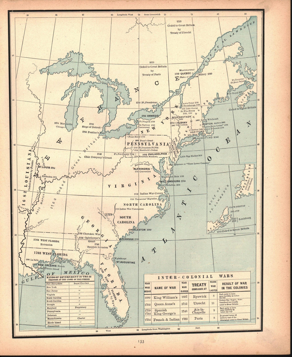
1887 Inter-Colonial Wars - Cram
$30.00
GEORGE CRAMInter-Colonial WarsContinent: North AmericaCountry: United States1887Lithograph, ColoredSheet Size 13.5 x 11 inchesPublisher: Henry S Stebbins, ChicagoVG+ condition with age toning, light soilingCartographer/Map Maker: George Cram


1887 Period of Constitutional Ratification - Cram
$30.00
GEORGE CRAMPeriod of Constitutional Ratification Early StatehoodContinent: North AmericaCountry: United States1887Lithograph, ColoredSheet Size 13.5 x 11 inchesPublisher: Henry S Stebbins, ChicagoVG+ condition with age toning, light soilingCartographer/Map Maker: George Cram


1887 Period of United States Expansion West - Cram
$30.00
GEORGE CRAMPeriod of United States Expansion WestContinent: North AmericaCountry: United States1887Lithograph, ColoredSheet Size 13.5 x 11 inchesPublisher: Henry S Stebbins, ChicagoVG condition with age toning, staining to lower rightCartographer/Map Maker:...


1887 Settlement of the 13 Colonies - Cram
$30.00
GEORGE CRAMSettlement of the 13 ColoniesContinent: North AmericaCountry: United States1887Lithograph, ColoredSheet Size 13.5 x 11 inchesPublisher: Henry S Stebbins, ChicagoVG+ condition with age toning, light soilingCartographer/Map Maker: George Cram


1887 Territorial Growth of the United States - Cram
Sold Out
GEORGE CRAMTerritorial Growth of the United StatesContinent: North AmericaCountry: United States1887Lithograph, ColoredSheet Size 11 x 13.5 inchesPublisher: Henry S Stebbins, ChicagoVG+ condition with age toning, light soilingCartographer/Map Maker: George Cram


1887 United States Maine - Cram
$50.00
GEORGE CRAMUnited States and MaineOn Verso, Map of MaineContinent: North AmericaCountry: United StatesState/Province: , Maine1887Lithograph, ColoredSheet Size 11 x 21.5 inchesPublisher: Henry S Stebbins, ChicagoVG condition with age toning, center...


1887 United States South America - Cram
$175.00
GEORGE CRAMUnited States South AmericaSouth America on versoContinent: North America, South AmericaCountry: United States1887Lithograph, ColoredSheet Size 17.8 x 23 inchesPublisher: AA Grant, New YorkVG+ condition with minor toning and spotting,...


1890 ABC Pathfinder Railway Guide Map
$135.00
ABC Pathfinder Railway Guide MapContinent: North AmericaCountry: United States1890Lithograph, ColoredSheet Size 27.25 x 24.5 inchesPublisher: New England Railway Publishing Company, BostonVG- condition with Toning to fold lines, splits to cross...


1890 ABC Pathfinder Railway Guide Map
$135.00
ABC Pathfinder Railway Guide MapContinent: North AmericaCountry: United States1890Lithograph, ColoredSheet Size 27.25 x 18.5 inchesPublisher: New England Railway Publishing Company, BostonVG- condition with Toning to fold lines, splits to cross...


1890 Cotton. Values and Yields per Acre.
$25.00
Cotton. Values and Yields per Acre.Continent: North AmericaCountry: United States1890Lithograph, ColoredSheet Size 13 x 8.8 inchesPublisher: Government Printing Office, WashtingtonVG- condition with Heavy toning


1891 Areal Distribution of the Columbia and Lafayette Formations - J W Powell
$275.00
J W POWELLAreal Distribution of the Columbia and Lafayette Formations of Southern United StatesContinent: North AmericaCountry: United States1891Lithograph, ColoredSheet Size 19 x 23.8 inchesPublisher: US Geological Survey, Washington DCVG+ condition...


1891 Coastal Plain of Southeastern United States during the Lafayette Period - J W Powell
$250.00
J W POWELLPhysiography of the Coastal Plain of Southeastern United States during the Lafayette PeriodPhysiography of the Coastal Plain of Southeastern United States during the Lafayette PeriodIssued 1891, Washington DC,...


1891 Coastal Plain of Southern United States - J W Powell
$275.00
J W POWELLPhysiography of the Coastal Plain of Southern United States during the Post-Lafayette and Pre-Columbia PeriodPhysiography of the Coastal Plain of Southern United States during the Post-Lafayette and Pre-Columbia...


1891 Coastal Plain of Southern United States - J W Powell
$275.00
J W POWELLPhysiography of the Coastal Plain of Southern United States during the Post-Lafayette and Pre-Columbia PeriodContinent: North AmericaCountry: United States1891Lithograph, ColoredSheet Size 19 x 23.8 inchesPublisher: US Geological Survey,...


1891 Coastal Plain of Southern United States - J W Powell
$250.00
J W POWELLPhysiography of the Coastal Plain of Southern United StatesContinent: North AmericaCountry: United States1891Lithograph, ColoredSheet Size 19 x 23.8 inchesPublisher: US Geological Survey, Washington DCVG+ condition with Page folds...


1891 United States
$125.00
United StatesContinent: North AmericaCountry: United States1891Lithograph, ColoredSheet Size 13.75 x 20.8 inchesPublisher: D. Appleton & Co., New YorkVG condition with light toning, few spots in image area, center fold as...


1891 United States USGS Topographic Survey - J W Powell
$275.00
J W POWELLMap of the United States Showing the progress of the Topographic Survey during the fiscal year 1890-1Map of the United States Showing the progress of the Topographic Survey...


1896 St Lawrence (Great Lakes) - Britannica
$40.00
BRITANNICASt LawrenceContinent: North AmericaCountry: United States, Canada1896Lithograph, Outline ColorSheet Size 10.5 x 15 inchesPublisher: The Werner Company, ChicagoVG condition with center fold as issued, toning to marginsCartographer/Map Maker: Britannica


1925 World Population Density - Joseph Meyer
$25.00
JOSEPH MEYERWorld Population DensityDie Bevolkerungsdichte Der Erde1925Lithograph, ColoredSheet Size 9.5 x 12.25 inchesPublisher: Bibliographisches Institut, LeipzigVG+ condition with light age toning, center fold as issuedContinent: World, North America, EuropeRegion: World...