

1891 Map of Iowa
$50.00
Map of IowaContinent: North AmericaCountry: United StatesState/Province: Iowa1891Lithograph, ColoredSheet Size 10.6 x 13.75 inchesPublisher: D. Appleton & Co.VG+ condition with toning to margins


1891 Map of Kansas
$95.00
Map of KansasContinent: North AmericaCountry: United StatesState/Province: Kansas1891Lithograph, ColoredSheet Size 13.75 x 20.75 inchesPublisher: D. Appleton & Co.VG+ condition with toning to margins, center fold as issued


1891 Map of Kentucky and Tennessee
$85.00
Map of Kentucky and TennesseeContinent: North AmericaCountry: United StatesState/Province: Kentucky, Tennessee1891Lithograph, ColoredSheet Size 13.75 x 20.75 inchesPublisher: D. Appleton & Co.VG+ condition with toning to margins, center fold as issued


1891 Map of Kentucky and Tennessee
$85.00
Map of Kentucky and TennesseeContinent: North AmericaCountry: United StatesState/Province: Kentucky, Tennessee1891Lithograph, ColoredSheet Size 13.75 x 20.75 inchesPublisher: D. Appleton & Co.VG+ condition with toning to margins, center fold as issued


1891 Map of Maine
$60.00
Map of MaineContinent: North AmericaCountry: United StatesState/Province: Maine1891Lithograph, ColoredSheet Size 13.75 x 10.6 inchesPublisher: D. Appleton & Co.VG+ condition with toning to margins


1891 Map of Michigan and Wisconsin
$100.00
Map of Michigan and WisconsinContinent: North AmericaCountry: United StatesState/Province: Michigan, Wisconsin1891Lithograph, ColoredSheet Size 13.75 x 20.75 inchesPublisher: D. Appleton & Co.VG+ condition with toning to margins, center fold as issued


1891 Map of Minnesota
$60.00
Map of MinnesotaContinent: North AmericaCountry: United StatesState/Province: Minnesota1891Lithograph, ColoredSheet Size 13.75 x 10.6 inchesPublisher: D. Appleton & Co.VG+ condition with toning to margins


1891 Map of Mississippi
$60.00
Map of MississippiContinent: North AmericaCountry: United StatesState/Province: Mississippi1891Lithograph, ColoredSheet Size 13.75 x 10.6 inchesPublisher: D. Appleton & Co.VG+ condition with toning to margins


1891 Map of Montana Idaho and Wyoming
$60.00
Map of Montana Idaho and WyomingContinent: North AmericaCountry: United StatesState/Province: Montana, Idaho, Wyoming1891Lithograph, ColoredSheet Size 10.6 x 13.75 inchesPublisher: D. Appleton & Co.VG+ condition with toning to margins


1891 Map of Nebraska
$55.00
Map of NebraskaContinent: North AmericaCountry: United StatesState/Province: Nebraska1891Lithograph, ColoredSheet Size 10.6 x 13.75 inchesPublisher: D. Appleton & Co.VG+ condition with toning to margins


1891 Map of New Hampshire and Vermont
$50.00
Map of New Hampshire and VermontContinent: North AmericaCountry: United StatesState/Province: New Hampshire, Vermont1891Lithograph, ColoredSheet Size 13.75 x 10.6 inchesPublisher: D. Appleton & Co.VG+ condition with toning to margins


1891 Map of New Jersey
$65.00
Map of New JerseyContinent: North AmericaCountry: United StatesState/Province: New Jersey1891Lithograph, ColoredSheet Size 13.75 x 10.6 inchesPublisher: D. Appleton & Co.VG+ condition with toning to margins


1891 Map of New Mexico and Arizona
$75.00
Map of New Mexico and ArizonaContinent: North AmericaCountry: United StatesState/Province: New Mexico, Arizona1891Lithograph, ColoredSheet Size 10.6 x 13.75 inchesPublisher: D. Appleton & Co.VG+ condition with toning to margins


1891 Map of New York
$75.00
Map of New YorkContinent: North AmericaCountry: United StatesState/Province: New York1891Lithograph, ColoredSheet Size 13.75 x 20.75 inchesPublisher: D. Appleton & Co.VG+ condition with toning to margins, center fold as issued
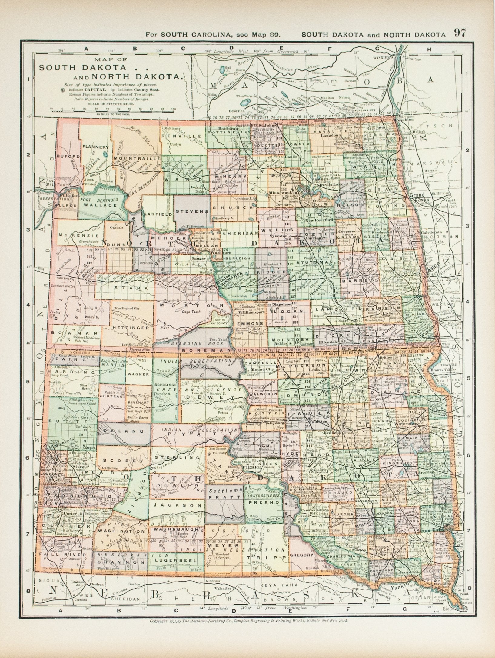

1891 Map of North Dakota and South Dakota
$60.00
Map of North Dakota and South DakotaContinent: North AmericaCountry: United StatesState/Province: North Dakota, South Dakota1891Lithograph, ColoredSheet Size 13.75 x 10.6 inchesPublisher: D. Appleton & Co.VG+ condition with toning to margins


1891 Map of Rhode Island
$60.00
Map of Rhode IslandContinent: North AmericaCountry: United StatesState/Province: Rhode Island1891Lithograph, ColoredSheet Size 13.75 x 10.6 inchesPublisher: D. Appleton & Co.VG+ condition with toning to margins


1891 Map of St Louis Missouri
$60.00
Map of St Louis MissouriContinent: North AmericaCountry: United StatesState/Province: MissouriCity/County: St. Louis1891Lithograph, ColoredSheet Size 13.75 x 10.6 inchesPublisher: D. Appleton & Co.VG+ condition with toning to margins


1891 Map of Utah
$75.00
Map of UtahContinent: North AmericaCountry: United StatesState/Province: Utah1891Lithograph, ColoredSheet Size 13.75 x 10.6 inchesPublisher: D. Appleton & Co.VG+ condition with toning to margins


1891 Map of Virginia Maryland Delaware and West Virginia
$85.00
Map of Virginia Maryland Delaware and West VirginiaContinent: North AmericaCountry: United StatesState/Province: Virginia, Maryland, West Virginia1891Lithograph, ColoredSheet Size 13.75 x 20.75 inchesPublisher: D. Appleton & Co.VG+ condition with toning to...


1891 Map of Washington and Oregon
$80.00
Map of Washington and OregonContinent: North AmericaCountry: United StatesState/Province: Washington, Oregon1891Lithograph, ColoredSheet Size 13.75 x 10.6 inchesPublisher: D. Appleton & Co.VG+ condition with toning to margins


1891 Ohio
$80.00
OhioContinent: North AmericaCountry: United StatesState/Province: Ohio1891Lithograph, ColoredSheet Size 13.75 x 20.8 inchesPublisher: D. Appleton & Co., New YorkVG+ condition with light toning, center fold as issued


1891 Pennsylvania
$70.00
PennsylvaniaContinent: North AmericaCountry: United StatesState/Province: Pennsylvania1891Lithograph, ColoredSheet Size 13.75 x 20.75 inchesPublisher: D. Appleton & Co.VG+ condition with toning to margins, center fold as issued


1891 United States
$125.00
United StatesContinent: North AmericaCountry: United States1891Lithograph, ColoredSheet Size 13.75 x 20.8 inchesPublisher: D. Appleton & Co., New YorkVG condition with light toning, few spots in image area, center fold as...


1891 United States USGS Topographic Survey - J W Powell
$275.00
J W POWELLMap of the United States Showing the progress of the Topographic Survey during the fiscal year 1890-1Map of the United States Showing the progress of the Topographic Survey...


1896 St Lawrence (Great Lakes) - Britannica
$40.00
BRITANNICASt LawrenceContinent: North AmericaCountry: United States, Canada1896Lithograph, Outline ColorSheet Size 10.5 x 15 inchesPublisher: The Werner Company, ChicagoVG condition with center fold as issued, toning to marginsCartographer/Map Maker: Britannica


1900 Fifth Lighthouse District - US Light-House Board
$125.00
US LIGHT-HOUSE BOARDFifth Lighthouse DistrictContinent: North AmericaCountry: United StatesState/Province: North Carolina, Virginia, Maryland1900Lithograph, ColoredSheet Size 20.75 x 16.75 inchesPublisher: Government Printing Office, WashingtonVG condition with Page folds as issued, toning...


1900 Part of the Third Lighthouse District - US Light-House Board
$125.00
US LIGHT-HOUSE BOARDPart of the Third Lighthouse DistrictContinent: North AmericaCountry: United StatesState/Province: Vermont, New York1900Lithograph, ColoredSheet Size 20.25 x 16.6 inchesPublisher: Government Printing Office, WashingtonVG condition with Page folds as...


1902 Geological Survey of New Jersey
$40.00
Geological Survey of New Jersey. A Map of New Jersey Showing approximately the area which would be submerged were the land to sink 50 feetContinent: North AmericaCountry: United StatesState/Province: New...


1902 Geological Survey of New Jersey
$40.00
Geological Survey of New Jersey. A Map of New Jersey Showing the Four Principal Topographic Divisions of the StateContinent: North AmericaCountry: United StatesState/Province: New Jersey1902, ColoredSheet Size 12.8 x 9.5...


1902 Geological Survey of New Jersey Volume V Plate LII
$35.00
Geological Survey of New Jersey Volume V Plate LIIGeological Survey of New Jersey Volume V Plate LII.Issued 1902, Trenton NJIn VG condition or better, page folds as issued.Sheet measures c....


1902 Moraine Between Plainfield and Ash Swamp, Union County
$35.00
Sketch of Moraine Between Plainfield and Ash Swamp, Union County1902Engraving, UncoloredSheet Size 20.75 x 9.5 inchesPublisher: MacCrellish & Quigley, TrentonVG+ condition with folded as issued.Continent: North AmericaCountry: United StatesState/Province: New...


1902 Sections of Kittatinny Valley to Coastal Plain
$35.00
Sections of Kittatinny Valley to Coastal PlainContinent: North AmericaCountry: United StatesState/Province: New Jersey1902Engraving, UncoloredSheet Size 26.25 x 9.5 inchesPublisher: MacCrellish & Quigley, TrentonVG+ condition with folded as issued.


1902 The Surface Geology Near Hamburg
$35.00
The Surface Geology Near HamburgThe Surface Geology Near HamburgIssued 1902, Trenton NJPage fold as issued, toning to fold lineSheet measures c. 10 5/8 x 9 1/2 InchesContinent: North AmericaCountry: United...


1902 The Topography Near Hamburg
$35.00
The Topography Near HamburgContinent: North AmericaCountry: United StatesState/Province: New Jersey1902Engraving, ColoredSheet Size 10.6 x 9.5 inchesPublisher: MacCrellish & Quigley, TrentonVG- condition with toning to center fold, folded as issued.


1902 The Topography South of Newton
$45.00
The Topography South of NewtonContinent: North AmericaCountry: United StatesState/Province: New Jersey1902Engraving, UncoloredSheet Size 24.5 x 19.8 inchesPublisher: MacCrellish & Quigley, TrentonVG- condition with Page folds as issued, splits to cross...


1913 U.S. Geological Survey Areal Geology Map of Niagara County, New York (Niagara Falls) - EM Kindle
$175.00
EM KINDLENew York. Niagara Quadrangle. Areal Geology.Areal Geology (Niagara Quadrangle)Survey by E. M. Kindle and Frank B TaylorIssued 1913, Washington DC, US Geological SurveyMinor chipping to upper right corner.sheet measures...


1913 U.S. Geological Survey Areal Geology Map of Niagara River, New York (Niagara Falls) - EM Kindle
$375.00
EM KINDLENew York - Ontario. Niagara Gorge. Areal Geology.1913Lithograph, ColoredSheet Size 49.8 x 21.6 inchesPublisher: U.S. Geological Survey, WashingtonVG+ condition with two folds as issuedContinent: North AmericaCountry: United StatesState/Province: New...


1913 U.S. Geological Survey Surficial Geology Map of Niagara County, New York (Niagara Falls) - EM Kindle
$195.00
EM KINDLENew York. Niagara Quadrangle. Areal Geology.Areal Geology (Niagara Quadrangle)Survey by E. M. Kindle and Frank B TaylorIssued 1913, Washington DC, US Geological SurveyMinor chipping to upper right corner.sheet measures...


1913 U.S. Geological Survey Topographic Map of Niagara County, New York (Niagara Falls) - EM Kindle
$175.00
EM KINDLENew York. Niagara Quadrangle. Topography.1913Lithograph, ColoredSheet Size 21.6 x 18.3 inchesPublisher: U.S. Geological Survey, WashingtonVG condition with Minor chipping to right margin, stamp in upper right margin.Continent: North AmericaCountry:...


1914 Geological Survey of New Jersey Newark - Henry Kummel
$45.00
HENRY KUMMELGeological Survey of New Jersey Newark SheetContinent: North AmericaCountry: United StatesState/Province: New JerseyCity/County: Newark1914, ColoredSheet Size 27 x 37 inchesPublisher: New JerseyVG- condition with wear and tear especially to...


1915 Areal Geology Ohio Columbus Quadrangle - G D Hubbard
$75.00
G D HUBBARDAreal Geology Ohio Columbus Quadrangle1912 map date1915, ColoredSheet Size 21.75 x 18.3 inchesPublisher: US Geological Survey, Washington DCVG condition with Repaired Split to upper right marginContinent: North AmericaCountry:...


1915 Surficial Geology Ohio Columbus Quadrangle - G D Hubbard
$75.00
G D HUBBARDSurficial Geology Ohio Columbus Quadrangle1913 map date1915, ColoredSheet Size 21.75 x 18.3 inchesPublisher: US Geological Survey, Washington DCVG condition with Repaired Split to upper right marginContinent: North AmericaCountry:...


1915 Topography Ohio Columbus Quadrangle - G D Hubbard
$65.00
G D HUBBARDTopography Ohio Columbus Quadrangle1912 map date1915, ColoredSheet Size 21.75 x 18.3 inchesPublisher: US Geological Survey, Washington DCVG conditionContinent: North AmericaCountry: United StatesState/Province: OhioLocality: ColumbusG D Hubbard


1925 Chicago Illinois - Meyer
$28.00
MEYERChicago IllinoisShowing Chicago Harbor and Lake MichiganContinent: North AmericaCountry: United StatesState/Province: IllinoisCity/County: Chicago1925Lithograph, ColoredSheet Size 9.5 x 6.25 inchesPublisher: Bibliographisches Institut, LeipzigVG+ condition with light age toningCartographer/Map Maker: Meyer


1925 World Population Density - Joseph Meyer
$25.00
JOSEPH MEYERWorld Population DensityDie Bevolkerungsdichte Der Erde1925Lithograph, ColoredSheet Size 9.5 x 12.25 inchesPublisher: Bibliographisches Institut, LeipzigVG+ condition with light age toning, center fold as issuedContinent: World, North America, EuropeRegion: World...


1927 Map of Prince George's County and District of Columbia - Edward Bennett Mathews
$125.00
EDWARD BENNETT MATHEWSMap of Prince George's County and District of Columbia showing the Topography and Election DistrictsLarge Map of Prince George's County and District of Columbia backed by linen ....


1930 - L P Plummer
$40.00
L P PLUMMERState of New Jersey Department of Conservation and Development Atlas Sheet No. 24Continent: North AmericaCountry: United StatesState/Province: New Jersey1930, ColoredSheet Size 36.75 x 27 inchesPublisher: State of New...


1938 Map of Greater Louisville Kentucky - Guy A Pease
$225.00
GUY A PEASENew Map of Greater Louisville Kentucky, Gateway to the SouthLarge 1938 Louisville Kentucky Railroad Map Canvas 1938.This was most likely originally a paper map, modified by hand adding...